Oakland Bay Bridge Gets New Air Gap Sensor to Aid Navigation
NOAA, in partnership with the Marine Exchange of San Francisco and the California Department of Transportation (CALTRAN), has installed an air gap sensor on the San Francisco-Oakland Bay Bridge. This sensor will accurately measure clearance under the bridge, allowing safe passage in and out of nearby seaports. Click here to view data from the sensor.This new sensor is part of NOAA's San Francisco Bay Physical Oceanographic Real-Time System or PORTS®. PORTS® provides accurate real-time information about environmental conditions in seaports, helping mariners and port operators to avoid accidents, safely continuing the flow of commerce in and out of the port.
Why are air gap sensors so important?
Many harbors are limited by the depth of the water and the height of the bridges leading into those harbors. Combine that with the increase in vessel size and traffic, and you have a recipe for an increased risk of a bridge collision. Some vessels may even avoid entering or departing a harbor entirely because of the limitations on bridge clearance. If a ship can't reach the harbor, then all the goods that ship is carrying won't make it either. This can hurt the local economy.How does an air gap sensor work?
NOAA air gap technology accurately measures the distance between the bottom of the bridge and the surface of the water flowing underneath through the use of microwave technology. In addition, NOAA uses a laser sensor as a quality control tool to verify the measurement. Having two different technologies taking the same measurement gives NOAA confidence that the measured clearance under a bridge is accurate.What other bridges have air gap sensors?
NOAA has developed this technology and is the only organization that installs air gap sensors for safe clearance in and out of seaports. NOAA has installed sensors on the following bridges:- Verrazano-Narrows Bridge (NY)
- Bayonne Bridge (NY)
- Reedy Point Bridge (Delaware)
- Chesapeake City Bridge (Maryland)
- Chesapeake Bay Bridge (Maryland)
- Don Holt Bridge (Charleston, SC)
- Dames Point Bridge (Jacksonville)
- Huey Long Bridge (New Orleans, LA)
- Crescent City Bridge (New Orleans, LA)
- Lake Charles I-210 Bridge (Lake Charles, LA)
- Gerald Desmond Bridge (Long Beach, CA)
- San Francisco-Oakland Bay Bridge (Oakland, CA)
About CO-OPS
The Center for Operational Oceanographic Products and Services, as part of NOAA's National Ocean Service, is an organization of experts in understanding tides, currents and water levels, and turning operational oceanographic data into meaningful information, products and services for the nation. This coastal intelligence provides timely, applicable information, developed from reliable and authoritative science. http://tidesandcurrents.noaa.govAdditional Information
- By a margin of 2.1 feet, the USS New York clears the Huey P. Long Bridge on June 27, 2009. | Download
- NOAA's Air Gap Technology Sends USS New York Down the Mississippi River for Sea Trials

Data on bridge clearance is updated every 6 minutes and shown in a visual image like the one above on the CO-OPS website here.
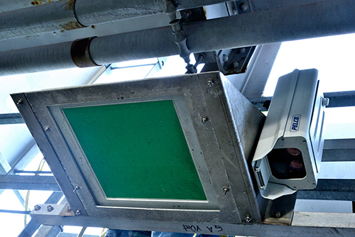
This image shows both the microwave sensor and the laser sensor that make up the air gap system attached to the San Francisco-Oakland Bay Bridge