NOAA Welcomes Two New Seaports as Part of the Physical Oceanographic Real-Time System (PORTS®)
Two southeast Louisiana shipping hubs, critical to the U.S. economy, are now part of NOAA's Physical Oceanographic Real Time System (PORTS®). The new multi-sensor systems will increase navigation safety and allow for increased efficiency on ships transiting through the Port of Morgan City and Port Fourchon, Louisiana.
Morgan City is a newly established foreign trade destination, serving as a gateway for goods and services to travel through the Intracoastal Waterway System and the inland rivers of the Upper Mississippi River Valley to reach markets in 37 U.S. states. Port Fourchon is one of the nation's busiest energy ports, servicing 90 percent of the deepwater Gulf of Mexico oil and gas industry. Each day Port Fourchon handles more than 20 percent of the nation's energy supply. It also serves as a commercial and recreational fishing mecca, foreign cargo shipping terminal, and a desirable area for recreation and tourism.
The Port of Morgan City is the 24th seaport to join the national PORTS® network. This system provides information on water levels, currents, wind speed and direction, air and water temperatures, barometric pressure, and salinity. Port Fourchon is the 25th seaport to use PORTS® and provides information on water levels.
Why is this system so important?
The majority of products you see on store shelves most likely traveled at some point on a ship, and the same holds true for American goods being exported overseas. The U.S. marine transportation system is the backbone for the movement of goods and services throughout the nation and abroad. However larger ships and an increasing volume of traffic in and out of seaports are pushing the limits of existing navigation channels and bridge heights. Bigger vessels and greater traffic means increased potential for accidents. That is where PORTS® comes in! PORTS® is an integrated system of oceanographic and meteorological sensors that provide mariners with accurate and reliable real-time information about environmental conditions in seaports. Having this information prevents accidents, saves lives and protects critical economic goods and services. Specific benefits include:- Reduction in ship groundings;
- Greater draft allowance (i.e., increased cargo capacity);
- Reduced transit delays for commercial traffic;
- Enhanced recreational activities;
- Improved environmental planning; and
- Hazardous spill response and accident response.
How does PORTS® work?
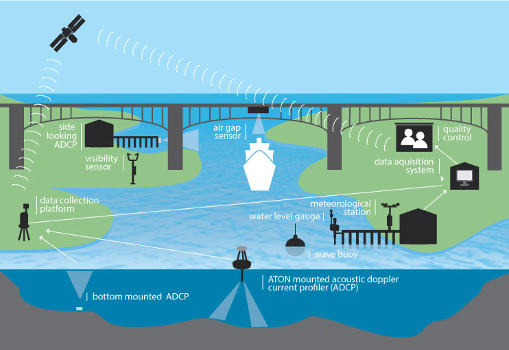
NOAA works with local communities to tailor the system to the specific requirements of each seaport. Sensors placed strategically in and around a seaport can provide information to mariners in real time, updated every 6 minutes. This information can include:- water levels
- current speed and direction
- bridge clearance
- visibility
- air and water temperature
- salinity
- wind speed and direction
- barometric pressure
- wave height, direction, and period
Where is PORTS®
This partnership program between NOAA and other federal and state agencies as well as industry, is in operation in 25 locations throughout the U.S. To access a PORTS® near you, click here.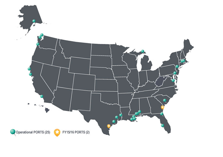
NOAA Operational Forecast System
In addition to the real time observations provided by PORTS®, NOAA also operates a national network of Operational Nowcast and Forecast Hydrodynamic Model Systems, or OFS, which provide a short-term forecast from present time out to 48 hours of key parameters for safe and efficient navigation, for example, water levels, currents, salinity, temperature, and waves. When coupled with a PORTS®, OFS models give mariners a more complete picture of both their present and future operating conditions, particularly important since conditions can change significantly and unexpectedly in a short time frame. To access an Operational Forecast System near you, click here.More Information
Port Fourchon PORT® dataMorgan City PORTS® data
Additional information on PORTS®
NOAA's Operational Forecast System
See the press release here