1-Minute Water Level Data
- Links
- Tsunami Capable Water Level Stations
- NOAA's Tsunami.gov Website
- Tsunami Warning Center Information
- U.S. Tsunami Warning System
- Deep-ocean Assessment and Reporting of Tsunamis (DART™)
- Pacific Marine Environmental Laboratory (PMEL)
- International Tsunami Information Centre
- National Tsunami Hazard Mitigation Program
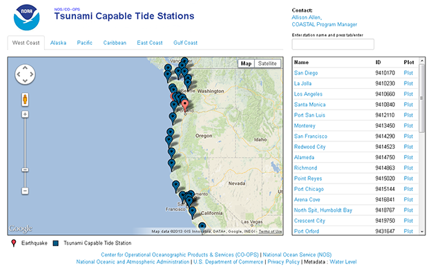
Tsunami Stations Map
The tsunami capable tide stations application at https://tidesandcurrents.noaa.gov/tsunami
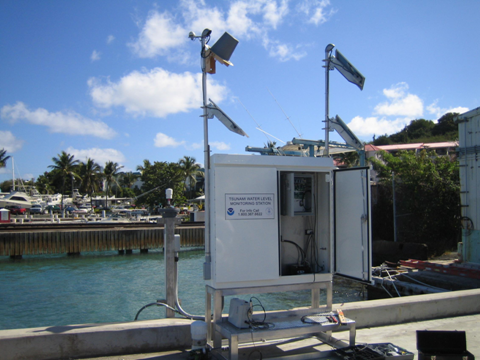
Currently, the primary application for high resolution, 1-minute water level data is to support national tsunami warning and mitigation efforts. Tsunamis pose a significant threat to coastlines around the world. Water level observations at coastal tide stations comprise a critical component of an effective tsunami warning system. CO-OPS has been involved with tsunami detection and warning for coastal hazard mitigation since the 1940's through the operation of a specific subset of its long-term tide stations in support of the national tsunami warning system. However, following the devastating 2004 Indian Ocean tsunami, CO-OPS began a system-wide upgrade of its instrumentation to increase the rate of data collection and transmission at all coastal National Water Level Observation Network (NWLON) stations: http://tidesandcurrents.noaa.gov/nwlon.html, to better support the National Tsunami Warning System's tsunami detection and warning capabilities, as well as to provide critical inundation model input. In addition to upgrading equipment at existing long-term NWLON stations, CO-OPS collaborated with the Tsunami Warning Centers (TWCs) and the Pacific Marine Environmental Laboratory (PMEL) to establish 16 new tide stations at high-priority locations in Alaska, the Pacific Islands, the West Coast, and the Caribbean, increasing the geographic coverage of water level observations in tsunami-vulnerable locations. This initiative was completed in 2007. At the current time, CO-OPS operates tide stations on all US coasts in support of tsunami warning.
Upgraded tide stations are equipped with new hardware and software to enable collection and dissemination of 1-minute water level sample data. In order to facilitate data transmission and dissemination, the NOAA TWCs receive water level data in a variety of ways. The Pacific Tsunami Warning Center, located in Ford Beach, Hawaii directly serves the Hawaiian Islands, the U.S. Pacific and Caribbean territories and the British Virgin Islands and is the primary international forecast center for the Pacific and Caribbean Basins. The National Tsunami Warning Center, located in Palmer, Alaska, serves the continental United States, Alaska and Canada (For more information on areas of responsibility, please see: https://www.weather.gov/safety/tsunami-twc)
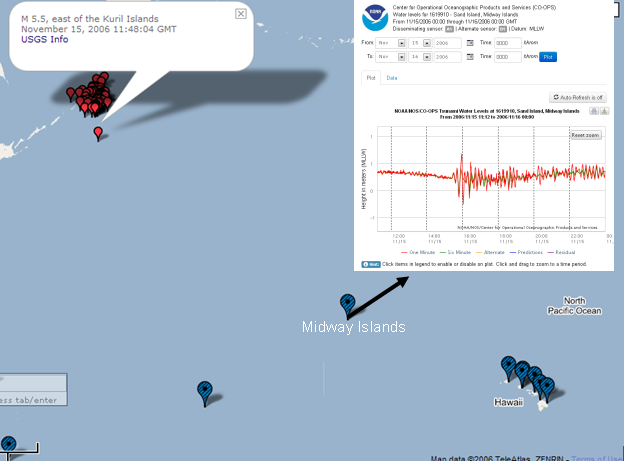
In addition to having access to raw water level data via satellite transmission, CO-OPS collaborated with the TWCs to develop a web page to disseminate 1-minute water level data. This web page allows users to view both 6 and 1-minute data numerically or graphically for all tsunami-capable tide stations in increments of up to four days. While data for a particular station or time period may not contain a tsunami signal, the high rate data collection provides easier detection of tsunami signals when these events occur.
Disclaimer: All water level data displayed through the CO-OPS Tsunami Web Page are raw and unverified. These data have not been subjected to the National Ocean Service's quality control or quality assurance procedures and do not meet the criteria and standards of official National Ocean Service data. They are released for limited public use as preliminary data to be used only with appropriate caution.
While CO-OPS disseminates this raw 1-minute water level data from its NWLON stations, the Tsunami Warning Centers are responsible for integrating these data with observations at Deep-Ocean Assessment and Reporting of Tsunami (DART™) buoys, coastal tide stations operated by the National Weather Service and international agencies, and seismic data collected by the National Weather Service and the US Geological Survey to issue tsunami warnings and guidance. NOAA also plays a role in hazard assessments (through forecast and inundation models), and preparedness and response. For more information about NOAA's role in tsunami warning guidance, and for links to contacts on specific non-water level questions, please see https://tsunami.gov.